The El Niño - Southern Oscillation (also known as ENSO) refers to a cyclical pattern observed in the tropical Pacific Ocean. There are three phases of ENSO - El Niño, La Niña, and Neutral. These phases relate to the ocean temperature anomalies that are occurring at any given time. If the ocean temperatures in the tropical Pacific are much warmer than average, then we are in an El Niño phase. If the temperatures are colder than average, we're in a La Niña. Climate.gov provides details on how exactly El Niño and La Niña conditions form. Read more...


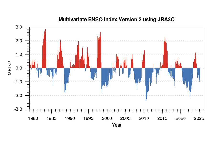
The below graph shows how the ENSO phase has changed (or oscillated) over time. A couple of the strongest El Niño events include 1997 and 1982-83. Stronger La Niña events occurred in 1988 and 2011-2012. NOAA's Earth Systems Research Laboratory gives a nice discussion about past El Niño and La Niña events. Read more...
It's hard to believe, but the changing temperatures in the Pacific Ocean can impact weather all across the globe! Over the United States, for example, El Niño conditions can result in a wet winter for the southeast and a dry and warm winter in the Pacific Northwest. This happens because those changing ocean temperatures drive changes in atmospheric pressure, the jet stream, and overall weather patterns. The North Carolina State Climate Office has a great ENSO page that discusses ENSO impacts on the U.S. Read more...


For Colorado, the story is a little more uncertain. The complex topography of our state, our distant location from the oceans, and our sensitivity to a lot of other variables, means that ENSO competes with a lot of other forces in determining what our weather will be like! So, while ENSO does play a partial role in Colorado's climate, it's not always a guarantee.
Explore the links below to see how El Niño and La Niña impact temperature and precipitation anomalies around the United States.
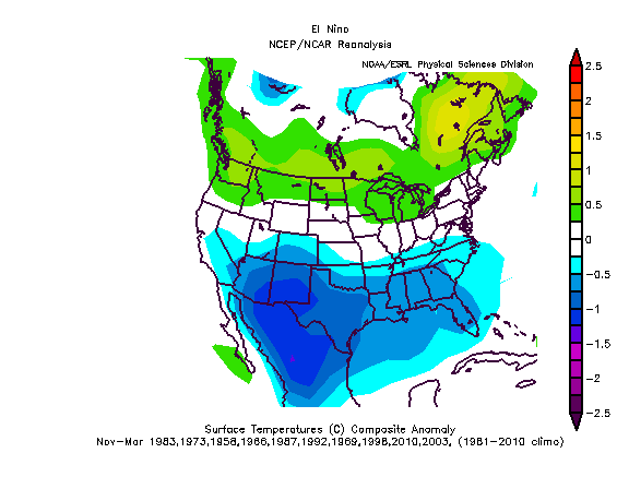
For Colorado, you may notice that the strongest signal shows up in wintertime temperature anomalies during an El Niño, when the entire state is likely to experience overall below average temperatures. During a La Niña, the eastern plains are more likely to see above average temperatures in the winter and summer.
When looking at precipitation, there's even more uncertainty! The most dominant signal shows up during La Niña summers. At that time, much of Colorado has tended to experience slightly below average precipitation.
During an El Niño, no signal shows up over Colorado. This may be surprising for some of you. Thinking back to winters of the past during particularly strong El Niños (like 82-83 or 97-98) you may associate major Front Range blizzards with those seasons. And when you look at the years in the composite, you'll see that one of our largest blizzards (March 2003) also occurred during an El Niño year. But that signal is just not consistent enough to solely attribute it to ENSO or use it as a forecast for future El Niño winters.
Current ENSO Conditions

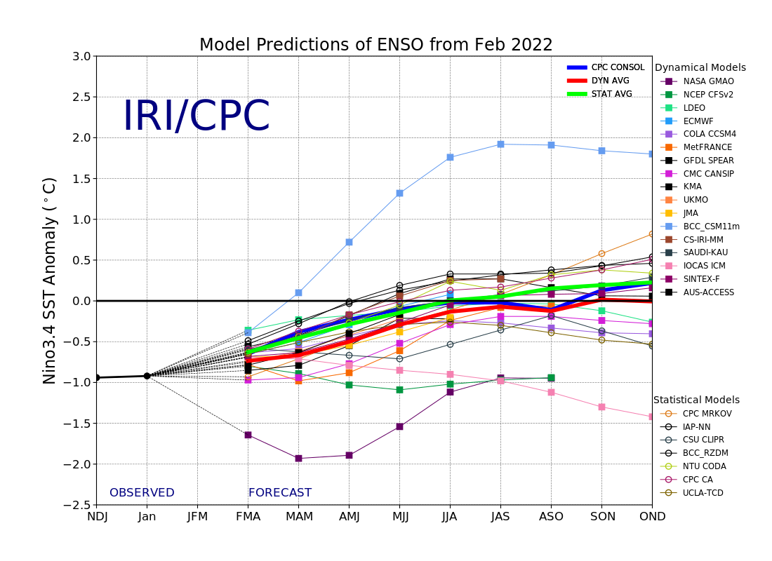
CPC/IRI PUBLISHED February 18, 2022 - In mid-February, Sea Surface Temperatures remain below-average in the central-eastern equatorial Pacific. The evolution of key oceanic and atmospheric variables is consistent with weak La Niña conditions, and therefore, a La Niña Advisory remains in place for Feb 2022. A large majority of the models in the plume predict SSTs to stay below-normal at the level of a weak La Niña until Mar-May, and then return to ENSO-neutral levels in Apr-Jun 2022. Similar to the most-recent official CPC/IRI ENSO Outlook issued on February 10, 2022, this objective model-based ENSO outlook also predicts a continuation of the weak La Niña event with high probability during Mar-May. However, there is a slight disagreement between the two forecast methods on the dissipation of the current event. The objective model-based forecast shows transition to ENSO-neutral during Apr-Jun (60% chance), while subjective consensus indicates the same happening in May-Jul (56% chance). Read More...
Outlook

ENSO News
Read the latest ENSO blog entry at Climate.gov - When rivers reach the sky
Snowfall patterns across the country during La Niña - What about snow during La Niña winters?